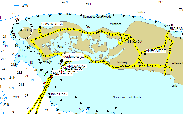
- We are in the Virgin Gorda North Sound. At least, that's where we think we are, because this sure looks like the North Sound.
- We are going to Anegada via the Colquhoun Reef channel.
- We will be sailing to the Anegada entrance channel, located about 0.75 miles southeast of Pomato Point.
- We know that the white roof of Neptune's Treasure is a good visual reference for locating the Anegada entrance channel.
- We sail to the Colquhoun Reef channel by visual navigation. Seeing the channel markers there confirms that, indeed, we know where we are.
- The chart says that Pomato Point is about 12nm due north of the Colquhoun Reef channel markers.
- We know that there is some current and we will have some leeway, so we will steer a course of about 020° and watch carefully for Anegada.
- About an hour later, we spot Anegada and steer to the trees at Pomato Point. When we can make out the white roof of Neptune's Treasure, we steer to it.
- About another hour later, we spot the channel markers, and steer to them.
- We watch carefully for hazards while we steer up the channel and into the anchorage.
- Select the main menu.
- Select Map Setup.
- Select Map Information (you may have to press the MENU button again).
- Select the BlueChart entry and press ENTER.
- Scroll to each of the charts that you wish to disable, then move the cursor over the checkbox to the left of the chart and press ENTER. Doing this should remove the check mark from the box, indicating that the chart has been disabled.
- When you press the QUIT or ESC button to go back up one menu level, you will see that the check mark in the box for the entire chart set is now removed. This does not mean that the entire chart set is disabled. It only means that one or more charts within the set is disabled. Selecting this box and pressing the ENTER button twice will re-enable all of the charts in the set, indicated by the check mark being in the box.
![]()
A prudent navigator relies on charted latitude/longitude position only on the macro-scale or meso-scale, but not on the micro-scale. That is to say, a good chart can tell you approximately what is at a given latitude/longitude, but not precisely. A good chart also shows the position of smaller details, with the position being accurate relative to other nearby features. To that end, almost all of the current navigation charts, either paper or electronic, work very well. For absolute position (latitude/longitude) they are almost all accurate to within a few hundred yards (meso-scale). For smaller distances (micro-scale), though, you must use relative position and your eyeballs to locate things -- not the charted latitude/longitude.
For instance, you can find the island Anegada with any nautical chart of the British Virgin Islands -- even the really cheap ones that are part of the typical charter-boat inventory. The chart will also show you that there are rocks and coral surrounding Anegada, and approximately where they are, relative to Anegada. Here's where the difference between meso-scale and micro-scale becomes important. The location of Anegada itself is macro-scale data, taken by a survey. The survey used for a particular feature on a chart may have been inaccurate by as much as a few hundred yards. Still, the chart data is sufficient and accurate enough for use on the macro- and meso-scales, and meso-features may be readily located by latitude and longitude.
Another way to say this is that a chart may have survey errors, but the errors are not over-the-horizon in scale. Pomato Point, near the western tip of Anegada, lies at N18°43.396' W 64°23.967'. If a chart is in error by a full minute of latitude, and shows the position as N18°44.4' W 64°24.0', you should still be able to find Pomato Point in good visibility conditions -- because you would first find Anegada itself, and then you would find Pomato Point by using visual references off of the island.
Rocks and coral and other small details, though, are typically no more than a few feet or tens of feet in size. On a chart, this is micro-detail, and its absolute position has the same inaccuracy as the macro- and meso- data. Many charts simply are not accurate in absolute position down to the scale of tens of feet. However, most charts do have accurate representations of the micro-scale position of features relative to each other and nearby meso-scale features.
Until the advent of GPS, very few recreational sailors ever attempted coastal navigation (as opposed to true open-ocean or blue-water navigation) solely by absolute latitude/longitude, and those that did accepted the inherent problems of performing accurate celestial navigation. Most of us simply used visual navigation coupled with dead reckoning. We would navigate something like this:
Notice that we used a chart only for relative positions. That is, positions of one thing relative to another. On the macro-, meso-, or micro-scale, this works just fine. Pomato Point is indeed about 12 miles north of Colquhoun Reef. With this knowledge alone, we can find it. The chart shows the channel entrance is about three-quarters of a mile southeast of Pomato Point. With this knowledge, and the ability to pick out Pomato Point, we find the channel entrance. The chart shows that there are rocks and coral to either side of the channel. With this knowledge, we avoid those hazards. Notice that nowhere did we ever use an absolute latitude/longitude position for the channel or rocks! All of our navigation was by relative position and dead reckoning.
With GPS, though, things are different. We now know our absolute position within a few feet. Precisely. We can navigate point-to-point without ever looking outside the boat. Precisely. The only problem is that the folks that surveyed the charts and marked where the hazards are may not have known their absolute position to that accuracy. What they did know, though, with fairly good certainty was the location of the micro-scale details relative to meso-scale features.
Our dilemma in the day of extremely accurate GPS positioning is that the rocks don't appear at the precise latitude/longitude that the chart says that they should be at. That is why we are now complaining that our charts are inaccurate.
This begs the question, "what is sufficient accuracy". If you are using latitude/longitude for meso-features, then sufficient accuracy is a few hundred yards. Inside that, you use your eyeballs and position relative to the meso-features that you can identify with the aid of a chart. If you are trying to use a chart for micro-features, then sufficient accuracy is a few feet. We are not going to have charts that implicitly have that kind of accuracy in our lifetime! To use a chart reliably for absolute position of micro-features, the chart must be verified for each micro-feature! Thus, almost all charts available today are plenty accurate, at least as far as the details that were there and charted at the time the chart survey was performed. Many of today's charts are out-of-date with respect to navigation aids, lights, buoys, etc., but the fact is that the land masses themselves are still charted with reasonable accuracy.
OK, now let's talk about GPS. My first GPS did not have a map or chart. It only told me basic navigation information, such as latitude/longitude position, and how to steer to get to a latitude/longitude waypoint. The waypoints that I recorded with it were absolute waypoints, not relative to any chart. In other words, it had no inkling of charted features. I charted some observed positions, and, in particular, saw that position that my GPS gave for the moorings at Leverick Bay plotted somewhere up on the mountainside on one of my charts. The chart was wrong by a few hundred yards in its location of Virgin Gorda. Another chart, however, was dead-on. This was the first time that I ever realized how much of a difference there was between charts.
I now have a super-duper GPS that has the most detailed nautical charts available. Still, the positions that it records are absolute positions. It knows the correct absolute positions of the Anegada channel markers only because it or another GPS was on the exact spot and recorded the positions. No human survey had anything to do whatsoever with the GPS's knowledge of those positions. However, it really has no idea of whether the beach at Anegada is in the right position or not, because that data is based on a survey whose accuracy is unknown.
On to electronic charts...
All electronic charts are based on paper charts. For instance, the Garmin BlueCharts of the British Virgin Islands that I use are based on USGS charts US25609, US25640, US25641, US25644, US25647, US25649, US25650, US25654, US25655, Russian charts RU21085, RU32624, British Admiralty charts GB2005, GB2008, GB2019, GB2020A, and GB2020B, and several Imray-Iolaire charts.
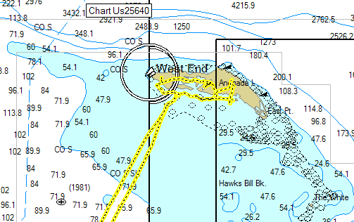
That is a lot of charts, and they overlap in coverage. They also differ in absolute position data. On a trip to the British Virgin Islands, I recorded our tracks almost everywhere we went, even ashore. On Anegada, I carried a GPS in our rental truck. Here are some snippets from the Garmin BlueCharts, showing our tracks.
This first one is on the Garmin MapSource 1nm software scale:

The next one is on the 5nm scale:

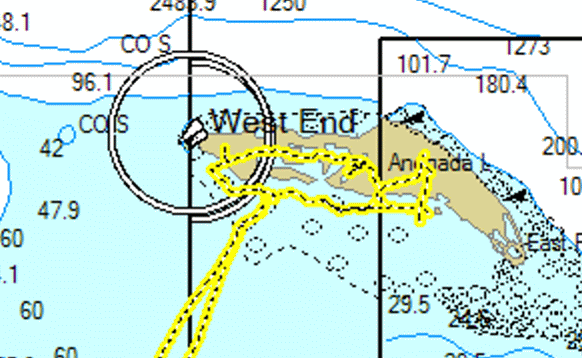
Here is an enlargement of it:

All three of these are absolutely correct, as far as our track goes. The difference is in the surveyed position of Anegada itself. On the 1nm scale, the GPS is displaying data from the GB2008 chart, and it appears to be quite accurate. On the 5nm scale, however, the GPS is displaying data from the RU21085 chart for Anegada. See the difference? If the RU21085 chart was correct, then I think Henrietta would have been pretty pissed about where we took her truck. The Russian charts are off by about a half mile in their position for the entire island of Anegada. Odds are, if we were using the Russian charts and doing celestial navigation, we would simply attribute the position error to errors in our sighting.
See the TWO lights at Anegada's West End on the 5nm scale chart? There is actually only one light there, but because the GPS is overlaying chart US25640 to the west over RU21085 to the east, with the juxtaposition you can see the visible chart differences.
This illustrates a very important point: the charts in your GPS are derived from printed paper charts, some of which may in fact have meso-scale survey errors, as illustrated above by the example from Russian chart RU21085. Don Street's Imray/Iolaire charts are also used in GPS map databases. Portions of the Imray/Iolaire charts of the British Virgin Islands were derived from the Russian chart series, and therefore also have similar meso-scale errors. Specifically, I have personally observed that the charting of the Anegada area on some of these charts is incorrect by a substantial amount, and have the geographic features in the Anegada area approximately 1 mile to the northeast of their correct positions. When your GPS is zoomed to certain ranges, these charts may be selected for the display. When this happens, depth and geographic features relative to your actual position and waypoints will be shown incorrectly. The point is that, until the nautical charts in your GPS are verified, you cannot even trust the depicted meso-scale geographical features.
Be wary of the geographical map data in your GPS each time you use it in a new area. Zooming the range in and out causes different charts to be referenced, so zoom to see the map display in different scales. Check to see that your eyeballs and your GPS agree. Remember that what you actually see is correct, the GPS geodetic position is correct, but the GPS chart data for that position may be incorrect.
When you discover that a chart is inaccurate on the meso-scale, you should manually disable the chart. Otherwise, you cannot be certain that the geographic information that your GPS is showing you is correct. When the charts are disabled, your GPS will simply select another of its charts that covers the area for that zoom range, and the depth and geographic features shown will be correct.
The method for disabling individual charts varies between manufacturers and models. For Garmin units in general, it works like this:
If you cannot disable a faulty chart, then (if possible) I suggest that you not download them at all to your GPS.
Sailors never before attempted to navigate by geodetic position on the micro-scale. We always relied on visual navigation and land features for micro-navigation. Micro-navigation by absolute latitude/longitude was a moot point. If it were too foggy to see micro-details, then it was also too foggy to use the sextant. When we could get a celestial sighting, the sextant would get us to within sighting distance of land, and the chart would tell us how to locate the micro-features relative to what we could see. We used our eyes to find that safe harbor. The best device for coastal navigation when using paper charts is a trusty hand-bearing compass.
In this day of high-precision GPS, we can only rely on observed and verified absolute waypoints for micro-navigation. For all unverified waypoints derived from charts or other references, we must still do the same thing -- use the GPS for macro- and meso-scale, and our eyeballs for micro-scale. Just as if it were a sextant, we can pretty much rely on the GPS to get us to within visual sighting distance of meso-features, and we must use a chart and our eyes for final location of micro-features. Simply put, we cannot use unverified waypoints for the degree of micro-navigation that is required to keep the fiberglass off the rocks or coral.
Another - and very accurate way - to describe using a GPS for micro-navigation is this (and this is my own little nugget):
"A GPS knows precisely (within a few feet) where it is. But a GPS does not know precisely where anything else is!"
I very strongly discourage ever entering a waypoint that was taken from a chart into a GPS. Once you pollute a good waypoint database with bad waypoints, you cannot distinguish an accurate waypoint that was actually taken with a GPS from a faulty one that was taken from an inaccurate chart.
Even with my recorded and trusted GPS waypoints, I still rely on my eyeballs for micro-navigation. I enjoy watching the GPS and seeing that the waypoints are really precisely where I marked them, but I am not relying on the GPS waypoints.
I am an instrument-rated pilot, and often fly our airplane in the soup. Even then, I use my eye-balls for micro-navigation. I rely on electronic navigation only to get me to within sighting distance of the runway. Common sense (and the FAA) says that if I cannot see the runway from 200 feet, then I cannot land. Even with the incredible electronic navigation gear in the airplane, I must still use my eyes for micro-navigation.
Definitions:
Geodetic position - Absolute position with respect
to earth, expressed as latitude and longitude.
Macro-scale - Global features, down to miles.
Meso-scale - Regional features, down to hundreds of
yards.
Micro-scale - Localized features, down to feet.

NOTICE THE AUTHOR MAKES NO WARRANTY, EXPRESS OR IMPLIED, AS TO THE ACCURACY OR COMPLETENESS OF THE INFORMATION CONTAINED HEREIN. |
This page and the contents thereof are the
property of Walker Mangum
Copyright © 2002, 2006 by Walker Mangum
All rights reserved
Images on this page may not be reproduced without the express consent of Walker Mangum
You are welcome to create links to this page.
