|
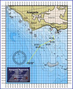
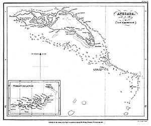
Sounding data for this chart was recorded at Anegada by Walker and Nancy Mangum on June 7-9, 2004, August 2-3, 2004, and June 19, 2006. An 11"x14" (scale 1:20000) printed copy of this chart is available from our online shop at shop.BVIPirate.com. This chart is a must for sailors that want to visit Anegada safely. It accurately depicts the approach to the anchorages at the western end of Anegada, including the Anegada Reef Hotel anchorage, Neptune's Treasure, and the Pomato Point anchorage. The shaded depth contours on the chart are in 2 foot intervals. Anegada is surrounded by dangerous reefs that have claimed over 150 vessels. Boats still go aground on the Anegada Reef very often. If you are sailing to Anegada, then using our chart along with the instructions on our Navigating to Anegada web page will make your trip safe and enjoyable. Note: All other printed charts and GPS data for this area are derived from surveys made over 150 years ago. Most other sources have incorrect depictions of the Anegada entrance. Groundings and serious injuries have occurred while navigating the Anegada entrance with up-to-date (but incorrect) electronic charts. Our chart is the only recent charting of the water near Anegada. |

|
NOTICE THE INFORMATION AND DATA ON THIS PAGE ARE PRESENTED FOR SUPPLEMENTARY REFERENCE ONLY, AND ARE NOT INTENDED AS A MEANS OF OR SUBSTITUTE FOR PROPER NAVIGATION AIDS. UNCHARTED AND UNMARKED HAZARDS EXIST. USE AT YOUR OWN RISK. DO NOT ATTEMPT PASSAGE TO ANEGADA WITHOUT APPROPRIATE CHARTS, BRIEFINGS, AND OTHER APPLICABLE INFORMATION. THE AUTHOR MAKES NO WARRANTY, EXPRESS OR IMPLIED, AS TO THE ACCURACY OR COMPLETENESS OF THE INFORMATION CONTAINED HEREIN. This page and the contents thereof are
the property of Walker Mangum |


